google map alternative(s)?
category: general [glöplog]
I was wondering , is there any alternative to google maps and microsoft virtual earth?
i tried them both for aerial / satellite stuff, while it worked great i'm wondering if some other services can give differents views or level of details...
I check NASA maps (updated daily they said) but its rather cloudy and you cannot zoom a lot...
also one other question : is the maximum zoom level limited by the amount of data that microsoft or google wanted to store (which should be, considering the number of tiles required, really big) or by the maximum resolution today satellites can reach ?

OpenStreetMap?

Quote:
or by the maximum resolution today satellites can reach ?
you meant 2004s satellites could reach ! ( which are the same, not counting them inofficial satellBITeS )

I don't know of other truly global services (with a reasonable detail) other than the 3 mentioned.
But for instance for denmark we have 2 companies (cowi and blominfo) doing the photos (sweeping with planes), and both have own gis webservices for it if you pay. So all (detailied) pictures on bing/google/eniro comes from one of them (updated every 1/2 years). Plus we have kms.dk collecting and reselling various data layers - actually they are to some extent available/usable without paying by using demo tickets ;)
But for instance for denmark we have 2 companies (cowi and blominfo) doing the photos (sweeping with planes), and both have own gis webservices for it if you pay. So all (detailied) pictures on bing/google/eniro comes from one of them (updated every 1/2 years). Plus we have kms.dk collecting and reselling various data layers - actually they are to some extent available/usable without paying by using demo tickets ;)


yahoo maps.

http://www.geoportail.fr seems to have some extra zoom levels in some places. But it is only for france.

Country-specific sites often have alternative data. I've seen other sites with satellite/aerial imagery for the UK that used to be better, although now between google + microsoft I think the others aren't all that good now. MS has a new "bird's eye" view using aerial images rather than satellite which can be a bit higher res. Also try google earth - it's the same data mostly, but you can view historical images (past versions of their satellite data).
I read a good article a while back about where the satellite data comes from, and what determines the resolution, but I can't remember where the article was now. From what I do remember, in most places the resolution is determined by the satellite's optics and image sensor. The newer satellites have really high resolution though, and for those images the resolution is limited because of privacy.
There's a lot of stories about the spy satellites and what kind of quality they can reach, saying they can read the headlines on a newspaper and such.. I think it's probably true. I saw a photo an amateur took recently, from the ground using a telescope. He caught the ISS, and you could make out the new window they'd just put in. It wasn't a great image, but he was getting probably similar resolution to the photos google use in google maps. This was with small-ish optics (the bigger the lens/mirror is, the more magnification you can get before hitting diffusion limits) and fairly regular imaging equipment, so the setup probably cost at most a couple of thousand dollars. With a bigger lens/mirror and high-end equipment you could push the resolution way higher. The only real limit would be budget (for space based stuff budget = weight pretty much, and optics get heavier fast as they get bigger) and atmospheric conditions (if there's turbulent air between you and the target, magnification is limited by that more than anything).

Photo from an "amateur" (which only means "not professionnal", because he rocks!) of the ISS + Atlantis shuttle in front of the Sun :

His website : http://legault.perso.sfr.fr/index_fr.html
His website : http://legault.perso.sfr.fr/index_fr.html

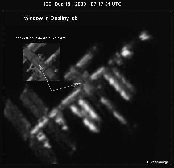
Taken with a 10" telescope, which is fairly big but nothing huge. The window is 50cm across, and 100km or so away.
And yeah, amateur pretty much just means 'self funded' for a lot of these people. With a big budget and a huge telescope they'd produce some awesome stuff. But probably much more boring stuff, as they'd be imaging what they get paid to image rather than stuff that's interesting ;)
great stuff. always love and respect the 'amateurs' best in everything.
